Letecké snímkování je extrémně drahá záležitost, nebo snad ne?Grassroots Mapping: How You Can Create Aerial Cartography for Under $100, and Use It to Do Good
Už jste se někdy ocitli v situaci, kdy jste potřebovali letecký snímek relativně malé oblasti, ale velmi aktuální, nejlépe pár hodin starý? V současné době neexistuje mnoho způsobů, jak si takovéto snímky pro svoje vlastní účely (diplomová práce, inventarizace zahrady, nízkonákladový výzkum) pořídit a pokud ano, tak se jedná o staré snímky, nebo ilegální či velmi drahé způsoby.
Historicky byly letecké snímky vždy výsadou státních orgánů a velkých firem; kdo jiný má také dostatek financí vypustit družici, nebo si zaplatit soukromé letecké snímkování. Za posledních 20 let se rozšířila nabídka firem, které prodávají letecké snímky i menších oblastí, avšak ceny a aktuálnost jsou většinou překážkou pro využití v “malých” a na aktuálnosti závislých projektech.
Jeffrey Warren z americké MIT univerzity představil koncept “Grassroots Mapping”, který vychází z myšlenky několika DIY (do-it-yourself = udělej si sám) kartografů. Díky jeho metodě je možné získávat letecké snímky malých oblastí za cenu okolo 100 USD, tzn. do 2 tisíc korun. Výhodou této metody je, že jakmile máme sestrojený přístroj, můžete snímkování opakovat v různých časových intervalech a získávat tak vysoce cenná a aktuální data za vámi zvolená časová období.

Metoda byla původně používána pro mapování chudinských čtvrtí v Peru, ale během ekologické havárie ropné plošiny BP v loňském roce byla využívána pro získávání aktuálních snímků oblasti ve vysokém rozlišení.
“Grassroots Mapping je jednoduchý a dostatečně levný nástroj, který může používat každý. Jakmile spojíte snímky dohromady získáte vysoce detailní obraz dané oblasti.” Jeffrey Warren.
Snímky ropné skvrny byly ve skutečnosti ve vyšším rozlišení než mapy NASA a NOAA, Google je licencoval pro použití jako oficiální vrstvu leteckého zobrazení oblasti na svém mapovém portálu a to stále při pořizovacích cenách v řádu tisícikorun.

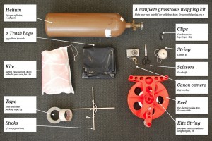
Principem metody je zavěšení obyčejného digitálního fotoaparátu s kontinuálním snímkováním na heliem plněný balón (lze vyrobit z plastových pytlů na odpad), nebo můžete fotoaparát zavěsit na kite/draka. V obou případech vypustíte váš přístroj a regulujete si velikost snímkované oblasti podle základního pravidla: “Výška přístroje=průměr kružnice snímkované oblasti”.
Pokud Vás tato metoda zaujala a chtěli byste si zkusit sestrojit vlastní mapovací přístroj, stránky projektu jsou plné návodů, videí a rad. Oficiální manuál naleznete zde. Než začnete sestavovat, nezapomeňte na základní pravidlo: vítr do 4,5 m/s je vhodný pro balón, vítr nad 4,5 m/s je lepší pro kite/draka. Napište nám, jaké metody znáte nebo používáte Vy. Jaké máte zkušenosti se získáváním aktuálních leteckých snímků malých oblastí?
Více informací naleznete na www.grassrootsmapping.org. Snímky jsou převzaty od Erin Sharkey, GonzoEarth na Flickr.com.
Historically, aerial mapmaking has been handled by governments and businesses alone. Who else could afford to put satellites in orbit or hire planes for private flyovers?
The notion that aerial imagery is only for the rich and powerful is being turned on its ear by an inspired group of DIY cartographers who have pioneered the field of grassroots mapping. The concept is simple: for about $100 in materials you can shoot aerial imagery that is higher resolution than any standard public satellite imagery. Using incredibly simple balloon and kite contraptions, you can capture the images on demand whenever you want, as often as you want.
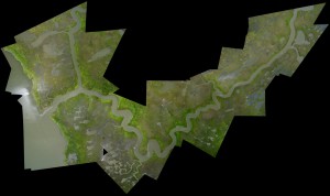
Jeffrey Warren of MIT’s Media Lab came up with the basic concept, which he calls „Grassroots Mapping,“ last year while working on a land-rights dispute in Lima, Peru. Then the BP oil spill happened, and the benefits of this method of mapping became urgently clear. Working with the Lousiana Bucket Brigade during the media blackout when FAA regulations prevented aircraft from flying lower than 4,000 feet above sensitive areas of the spill, Warren and the Grassroots Mapping team flew balloons and kites and captured incredibly vivid images of the oil spill’s impacts. Using simple online cartographic tools, the photos can be stitched together into bigger maps, like this one of the Lake Borgne wetlands east of New Orleans captured on June 11th of last year.
Of the oil spill work, the Grassroots Mapping team explained:
„We’re helping citizens to use balloons, kites, and other simple and inexpensive tools to produce their own aerial imagery of the spill… documentation that will be essential for environmental and legal use in coming yeas.We believe in complete open access to spill imagery and are releasing all imagery into the public domain.“
The beauty is, as Warren explains in the video below, „the tools are simple and cheap enough that anyone can use them…Once stitched together, these form some of the most detailed maps ever made of the oil spill.“ So detailed, and such high resolution—higher than NASA’s and NOAA’s maps, in fact—that Google licensed the images to use in the aerial layer of their maps of the region.
Now the Grassroots Mapping project is spreading far beyond the Gulf Coast. Maps are being used to monitor mining sites, assess ongoing or sudden environment damages, observe coral reef health and degradation. This video explains more:
Today, Grassroots Mapping has evolved into a broader effort called the Public Laboratory for Open Technology and Science (PLOTS), which „collaboratively develops and publicizes accessible technologies for investigating and reporting on local environmental health and justice issues.“
If you want to start creating some grassroots maps of your own, the PLOTS site—fully loaded with lessons, tools, templates and links to supplies and software—is a great place to start.
I particularly this elementary piece of advice: the rule of thumb is, less than 10 miles per hour of wind is good balloon weather, more than 10 miles per hour of wind is good kite weather. For a look as some citizen mappers working in the notoriously polluted Gowanus Canal area of Brooklyn, OnEarth has a great story and slide show. We’ll put together our own slide show soon of the best images from this nascent, crucial movement.
By BEN JERVEY, originally published at GOOD.is
Aerial imaging acquired by grassroots mapper Erin Sharkey. Image (cc) by GonzoEarth on Flickr.


